
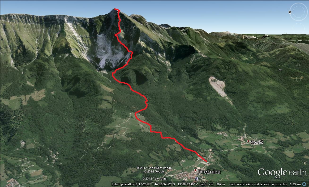
Starting point: Drežnica (553 m)
Destination: Krn (2244 m)
Time of walking: 5 h
Difficulty: very difficult marked way
Altitude difference: 1691 m
Access to starting point:
From Tolminske direction: from Kobaridom (200m to the Petrol station), turn right on the (council) and the new crossroads again on the right (the board), continue across the bridge where you turn to the left. In the center Drežnica turn to the right and zapeljemo to primary school where the starting point of our journey.
Bovec region in the direction of: the intersection before Kobaridom follow the (new) bypass and the first intersection, turn left (council). From here the same as in the direction of Tolminske.
Path description:
The parking lots are focusing our past chapel and primary schools on the way to markirano Krn. The path leads through the forest and pasture to the table at the Triglav National Park. You connect the road from Dreznica, which is about to end. When you cross a stream Ročica get to the direction in which the focusing left in the direction of bivaka. The way forward is summarized in the woods and moderate climbs in the vicinity of the river Ročica. The path then turns slightly right and we will soon lead to bivaka to Črniku.
Bivaka from the hard left and continue on the path continues to climb through the woods. When we get from the forest, turn left and after a short prečenju slopes below Born Krna soon enter the part of the way plezalni. Right from the beginning is almost vertical vzpnemo through Staples and jeklenice. After the first steep climb the path turns slightly left and becomes shorter somewhat less demanding. Having followed jeklenici climb and then climb the keys to very steep and a non grassy slope. In the wet this part of a very dangerous for Skating. The path then turns right and leads to a crossroads. The right path crosses exposed western slopes Krna and be connected with the mountain paths and easier Kitchen (Southern) path with Drežnica. We are focusing on the intersection left on the path Silva Korena. The path takes place on a very steep and exposed ridge, which is well protected. Such a path leads to the entry books, which is located before the most vulnerable part of the journey. The path takes place on a relatively narrow and prepadnem ridge where the vzpnemo twice in the vertical ladder. The path then us in a few steep ascents at jeklenici lead to Gomiščkovega shelters in the Krnu. There is also ending part of the way plezalni. From then, we have shelters for about ten minutes walk to the top of Krna. For Descent is recommended to use the south easy way.
More pictures of mountain trail get to the link below:
http://www.hiking-trail.net/hiking_trip/dreznica_krn_silvo_koren_route/1/150/1073

Pingback: HIGH ATOP MONTE NERO, THE COLONEL WEPT - MAGIC OF KRN - Meandering through the PrologueMeandering through the Prologue